

“Changing perceptions and implementing a program that focuses on ‘soft’ and progressive action in the immediate to short term rather than ‘hard’ longer-term action is a way to create an ecosystem in which infrastructure fully accommodates physical and organic processes.”
Jérôme Baratier, Director of the Tours urban planning agency.
Building on territories’ collective imagination: an efficient method.
The physical dimension of existing projects or structures is neither a unique consideration nor even the primary one. They have a strong functional and symbolic worth as well, whether positive or negative. In this sense, they are also mental objects. The environment that they are part of is not only material or natural, but also imaginary. Knowledge of the symbolic representations of the territory is essential to the project’s fitting into this existing environment, namely its capacity to respond to high expectations, even where they are implicit. Only a transdisciplinary approach to territory can bring these expectations to light. Appropriate analysis tools from the Method: “Use, Symbol, Structure” foster the emergence of needed projects that are based on consensus.
Purpose and content
This paper offers a complementary intellectual and operational approach to classical engineering studies, with a view to enhancing project conception in such a way as to foster its acceptance by all stakeholders.
Scope
This new approach is aimed at internal and external teams working on urban planning and infrastructure project conception, in particular during the consultation phase. It is applicable to the optimization of organizations.
Find out more on video: “Urban integration in Tours” (16 minutes)
An interdisciplinary case study on Tours’ integration of the A10 highway: anthropology, mythology, urban psychoanalysis, and map deconstruction, among others.
>> Watch here [in French only]: http://vimeo.com/user34840685/integrationurbainetours
1 A few basic notions
1.1 There is more to a project than the built structure
The engineers building an infrastructure perceive it essentially as a physical object. However, it is also a human adventure, the result of multiple efforts and know-how, and a contribution to the common good of the territory that receives it. There is an immaterial symbolic component associated with the project’s realization from its earliest stages.
The same is true for the elected representatives and technicians of the commissioning community, although the lived history may be experienced in different ways, as well as for nearby residents and users. The latter undoubtedly see the physical object, but also its desired or feared impact on their living environment and freedom of movement. Their perception of the infrastructure is determined by the use that they or other users make of it or of which they bear the burden.
Stating these obvious ideas is one thing; drawing the implications thereof is another. First of all, this means that the world we live in is not limited to its physical dimension. The latter is only the foundation into which traditions, experiences and symbolic representations are embedded, for better or for worse. In the early stages of intentional design, the infrastructure is already the subject of debate, wishes and fears to which the engineer’s rationality can provide only part of the answers.
In today’s world, the efficiency of purely technical approaches is declining. It fails in particular to tackle the major issue of project acceptance by all stakeholders on the territory, namely communities, nearby residents, users and opinion leaders such as associations and the press among others.
Other methods must be used.
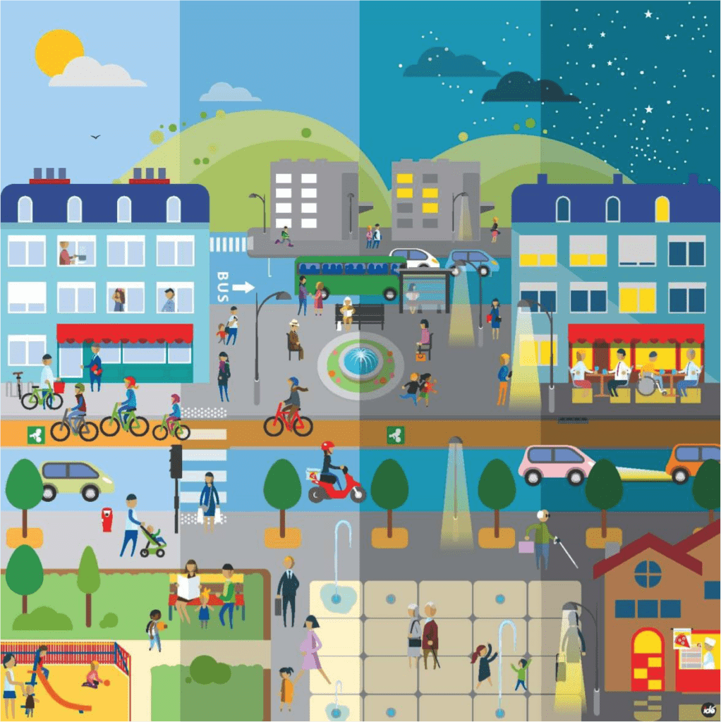
1.2 Becoming part of an environment is occupying a place in the collective imagination
The imperative to incorporate any new infrastructure project harmoniously into the existing environment is now unanimously acknowledged, and this environment goes well beyond its physical or natural dimensions. To a large extent, it belongs to the realm of the imagined; in other words, it is made up of more or less conscious, subjective and shared mental representations. They are related to the customs, traditions and culture of the territory concerned.
A simple example would be a city through which a river, a railway and a highway run. Each of these three objective dividing lines is perceived and accepted differently by the residents, depending on the history, customs and abstract representations that they attach to them. The river’s identity dimension and the economic and proprietary gains derived from the railway produce acceptance if not genuine attachment, unlike the highway, which is perceived as useful, but also harmful.
Whatever the objective “reality” may be, it is through these mental representations that any highway-related project, such as widening, covering and deviation, will be viewed by stakeholders. Ignoring this fact is risking deadlock. On the contrary, when these abstract representations are taken into account, they can be incorporated into the project, allowing it in turn to find its rightful place within the collective imagination of the territory.
Since the project hinges in large part on collective imagination, the conception phase must include a Project in the imagination, which will help to wed it with the collective imagination of the territory.
1.3 To get a clear view: look closely and cross perspectives
Understanding the territory begins by taking a close look.
What does taking a close look consist in? It consists in applying to an object a grid of perception that is both sensitive and culturally and rationally oriented. A territory is seen differently according to whether the individual is a city dweller or living in a rural area, an engineer or an artist, a car driver or a pedestrian. The lens through which each observer perceives a given reality produces multiple representations that are all equally valid and legitimate.
Yet these representations are not impervious to one another. On the contrary, crossing perspectives enriches the perception of the individual observer. When there are several observers, they will see more. Likewise, overlaying several grids will produce more than one meaning.
On the other hand, one only sees what one is trained to see and is looking for. In order to understand customs and symbolic representations which hold importance for the project, it is also necessary to call in experts in disciplines such as urban planning and anthropology.
A merely pluridisciplinary approach would fall short of this goal; transdisciplinarity is needed. We seek precisely the crossing of perspectives rather than their juxtaposing.
2 The step-by-step method: “Use, Symbol, Structure”
2.1 Transdisciplinary exploration of the territory
Project conception starts with an exploratory phase mobilizing experts in various areas: engineering, architecture, urban planning, landscape planning and anthropology, to name a few. This phase focuses on collecting any useful information regarding the physical, urban and symbolic environment of the project.
Exploration is done in particular through informal contact with individuals who agree to share accounts, information and various anecdotes that can help the design team acquire an understanding of the territory.
The collected information is composed of individual accounts, which put together, reveal a collective narrative.In this study, intended as a contribution to a future book project, we use three conceptual tools to structure exploration: the Magic Square, lifelines or flowlines, and break lines.


The Magic Square
The Magic Square helps guide the exploration and classify the collected information according to three topicson the one hand, and according to three territorial levels on the other. The Magic Square contains only nine boxes for greater concision and it can be adapted to the nature of the project, as illustrated through the examples below.
Magic Square of a city by-pass project
| Immediate surroundings (radius of 1 km) | Conurbation (radius of 10 to 20 km) | France | |
| Territory’s identity | |||
| Mobility | |||
| Biodiversity |
Magic Square of a tramway project
| Immediate surroundings (radius of 100 m) | Neighborhood (radius of 100 to 1000 m) | Conurbation (radius of 1 to 10 km) | |
| Mobility | |||
| Daily life | |||
| Collective imagination |
The choice of symbolic themes is anchored directly in the broader social expectations of residents and users of the extended territory.
For a city bypass:
- The subject of identities is always high on the agenda at each of the scales. We are from a given neighborhood, village, agglomeration, region, etc.
- Then as the focus is on transportation infrastructure, the subject of modes of transport must be addressed. Now we are speaking of modes of transport and referring to usage, not networks or infrastructure, and especially not to a specialized network such as “the road network.” Sectoral approaches are to be banished.
- Finally, as soon as we address a complex territory comprising suburbs, biodiversity issues always come to the forefront of social expectations, for neo-rural dwellers because they live there, for residents of the city centre because they walk there (or not, but want to keep nature close to the city)
For a solely urban project such as a tramway line
- The subject of identities is more homogeneous for a tramway line; however, the imaginary elements that confront the project are very diverse, depending on each city block.
- Then, once again, as the focus is on transportation infrastructure, the subject of modes of transport must also be addressed for a tram. Now we are speaking of modes of transport and referring to intermodal usage: how we get to the tramway station, are bicycles allowed on the tram, and park and ride lots, among other elements.
- And finally “we circulate, we stop and we live next door”, i.e. the third deliberately vague theme of “daily life” which emerged after a few door-to-door interviews. A tramway station is also a living space.
The purpose of this work is not to publish a study. The process is more important than the result, i.e. the appropriation by each practitioner of the stories told by others.
Its primary audience is the project team extending to all beneficiaries so that they incorporate the territorial subjects into their own production. We then select less than 10% of the gathered material to help high-visibility complementary ideas emerge.


Lifelines or flowlines
This study identifies in particular the lifelines or flowlines that users in the territory take in the course of their daily activities or during major events in order to access facilities related to the following:
- Mobility: train stations and road infrastructures
- Work: areas of activity and business districts
- Culture and recreation
Break lines
Finally, the analysis of the territory focuses on break lines, in other words physical or symbolic barriers that affect the functioning of urban space or residents’ daily lives.
Physical barriers include impassable elements or hindrances to mobility such as
- Obstacles: fast lanes, railway tracks, watercourses, and enclaves
- Stops: tollgates, intersections, traffic congestion areas
Symbolic break lines can be explained through factors such as
- Historical: enduring memory of physical barriers that have ceased to exist
- Cultural or social: sensitive demarcation lines between neighborhoods
- Aesthetic: visible degradation of the urban environment
- Psychological: anxiety-provoking elements, nuisances, taboos and prohibitions
2.2 Cognitive map of the project in its environment
The crossed perspectives on the project’s environment have not only allowed for identification of the possible causes of deadlock, but also of the levers for stakeholder adherence to the project. The various data combined will enable the conception team to represent the project’s environment in the form of a multidimensional cognitive map, in other words an accurate portrayal of the manner in which users imagine it. Marking the infrastructure project on this map reveals its potential interactions with the following:
- The physical environment, in particular barriers
- Uses, in particular lifelines and flowlines
- The collective imagination of the territory, in particular symbolic break lines
The cognitive map of the project in its environment points to issue sectors where the project creates or faces break lines, crosses flowlines or touches on strong symbolic elements.
2.3 Action plan and the creation of a project in the imagination
The cognitive map of the territory inspires concrete ideas as to how to direct and enhance the infrastructure project on the level of uses and symbolic representations. These ideas are classified in order of importance and then picked out to create an action plan according to the following criteria:
- Location within issue sectors
- Symbolic value or use value
- Ease of integration into the project
- Cost
Another criterion taken into account in the establishment of the action plan is the plan’s overall coherence to the benefit of the project in the collective imagination, which in turn must be congruent with the territory’s collective imagination.
The objective is to combine these actions into a proposal that lays out distinct benefits for stakeholders.
Within the logic of the aforesaid, the infrastructure can bring the following three types of potential benefits:
- Physical: material and aesthetic qualities of structures and facilities
- Functional: meeting needs in terms of use (including environmental needs)
- Symbolic: mental representations triggered by the project or support measures
The more these benefits echo and interact positively with one another, the more comprehensible and relevant to stakeholders’ collective imagination the project will be.
Uses and representations are essential in the construction of the collective imagination around the project. They will ensure that the project becomes a shared dream, in other words a valid as well as a welcome object.
3 Examples of implementation
3.1 Nantes: laying the foundation for the co-construction of a project
In 2013, the state granted the widening of the northern section of the Nantes bypass project to a concession-holding company. Historically this “tramway city” has been very committed to public transit, and at the time, the Notre-Dame-des-Landes airport project was being vigorously challenged. The bypass project could therefore only be considered in the form of a co-construction.
In order to initiate and get the project off the ground, we decided to create a cognitive map of the collective imagination of the residents of Nantes. Research was assigned to urban planning students who were foreign to the city and could therefore approach it without bias. Investigation proved doubly useful: by providing precious information on the use of the territory and on its residents’ mental representations on the one hand, and by drawing the attention of key persons to our project on the other.
We were pleasantly surprised to see Nantes’ mayor begin to follow the Imaginaires de Nantes (Nantes in the collective imagination) Twitter account 24 hours after the students set it up. The person in charge of mobility for Nantes Métropole, who originally called us to find out more about our intriguing research, carried out partly on the streets, proceeded to invite and meet with the students and finally opened the door to contacts with other administrations. The foundations were in place for an open and constructive reception of the project.
The project now continues steadily in the legal public consultation phases.


3.2 Tours: understanding social demand beyond political considerations and designing an action plan tailored to these needs
The City of Tours asked the concession company to propose solutions aimed at reducing the highway’s impact in the centre of the conurbation between Tours and Saint-Pierre-des-Corps. What was this impact specifically?
In conjunction with the urban planning agency, we started by exploring the way in which the highway is used and is perceived in the collective imagination.
Initial analysis revealed that the cartographic representations of the territory accentuated the layout of the highway, making the barrier appear bigger and more impassable than it actually is. Its impact on the perceptions of the infrastructure was anything but neutral.
That alone shows that the symbols (graphic in this case) associated with the highway can determine residents’ perceptions as much as the structure itself, if not more so. There is nothing to suggest that covering the highway, for instance, might improve perceptions if they are related to something other than the noise and visual impact of the traffic.
On the flip side, we can probably change perceptions by addressing symbolic objects.


This aerial photograph that we have colorized shows the “real” hierarchy of physical obstacles to traffic flow in the centre of the conurbation of Tours. On top we see the Loire region, at the bottom, the region of Cher, and in black, the railway tracks. The highway is the red line connecting the various parts of a fragmented territory.
To go further, we conducted a transdisciplinary assessment combining urban psychoanalysis, landscape perception, and anthropology. It revealed that the highway is not experienced as a foreign body within the city, but instead as the most recent development in a “family story” made up of complementarities, tensions and break-ups between Tours and Saint-Pierre-des-Corps, whose longstanding separation was due to a canal, which the A10 replaced.
This assessment is very enlightening in regards to the goal to be achieved. It has less to do with “reducing the impact of the highway” (protection) and more to do with better fitting it in the city (receptivity). The action plan we propose follows directly from this understanding. The following four examples of simple and low-cost actions can be implemented to this end:


Open up the highway to city buses on sections crossing Tours where the speed limit is 90km/h. This is one way to connect the highway to the city


Enhance the symbolic intersection of the highway and the “Loire by bike” bike path, frequented each year by tens of thousands of tourists.
The image on the right depicts the striking gap between what the website promises (above) and reality (below).


Involve nearby residents in the creation of sculptures erected along the highway to mark and enhance neighborhoods. This approach is at one and the same time educational (with the participation of school children), artistic, and unifying in terms of tying highway and territory together.
Left: comic strip narrative of the project.


Give nature a chance (a €10 project). Planting additional Virginia creeper seedlings at a block party event with support from a family garden association is a great way to complete the natural revegetation of a structure. Time will do the rest and the concrete will gradually disappear under the green cover.
3.3 Strasbourg: Combining the functional and symbolic benefits of the project
In 2014, the government launched consultations on the construction and use of a major bypass west of Strasbourg (25 km). The project was controversial because of the anticipated environmental impact and perceived by its critics as an incentive for the transit of heavy vehicles with no commensurate benefit for the Alsace region, or as a new barrier imposed from outside. Furthermore, the protection of the Great Hamster of Alsace, a threatened species, had also previously interfered with the project.
We are in the process of conducting an anthropological study in order to grasp the underlying levers for opposition to the project. The study outlines contrasting perceptions as well as a collective imagination based on identity issues and unifying symbols. We found out for instance that, a few decades ago, capturing the Great Hamster of Alsace, considered a nuisance for farming, was encouraged. Elders recall that in their childhood the best trappers among them got bicycles in exchange for their trophies. Conversely, we suggest establishing a double network of hamster shelters and bike paths parallel to the infrastructure. From a feared frontier, the bypass can thus be turned into a local bond defending a symbol of Alsatian identity.


Drawing done by an Alsatian
4 Conclusion: Advantages of the Use, Symbol, Structure method
Our method enables structures to better meet the needs of populations. It also proves efficient for project leaders, from the initial phase through to implementation and beyond.
- During the conception stage, it allows for the demand to be enhanced and reformulated through added accuracy or pertinence. Use-related issues are reconsidered. Symbolic stakes, often ignored in project specifications and programs, are identified and incorporated. A proposal developed on these foundations is necessarily more convincing.
- This method also provides differentiation elements to the project. Insofar as they operate on the level of the collective imagination and shared dream, they are potentially decisive at the moment of choice.
- Based on involvement, attentive listening and interaction in person, the Use, Symbol, Structure method is also a way to build a local network of informants or individuals who contribute ideas and who are potential allies with respect to the project. This co-construction process is useful in terms of conception and also in terms of potential adherence to the project, for which these preliminary contacts lay the groundwork.
- Based on these qualities, the method is very workable as it contributes directly to fostering acceptanceof the project by decision-makers, observers and future participants in the operation.
The Use, Symbol, Structure method generates no substantial additional cost or longer timescales. Studies of an anthropological nature are easy to manage. The entire process extends over approximately three months and yet it enhances cost efficiency. The process results in identifying meaningful actions which considerably reinforce the symbolic value and use of the project at minimal cost.


To conclude
Serving the people, inhabitants, users, economic stakeholders, visitors, … of the territory, by the method “Uses, Symbol, Structure” deploy your collective talents of “Urban Vibes Designer”